
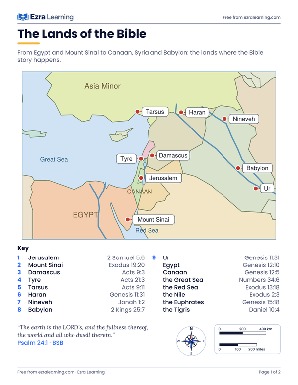
The Lands of the Bible
Egypt, Canaan, Syria and Babylon on one map, labeled and blank.
Psalm 24:1 BSB: The earth is the LORD’s, and the fullness thereof, the world and all who dwell therein.
Free printables › Free Bible Maps
Twenty printable maps of the lands of the Bible, each with a labeled page and a blank page to fill in.
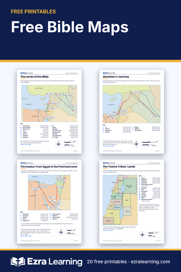
A map turns a name in your Bible into a place you can point to. These twenty free maps follow the Bible from Abraham’s journey out of Ur, through the Exodus and the twelve tribes’ lands, to the cities where Jesus taught and the sea roads that Paul sailed to Rome. Every map has two pages. The first page is labeled, with a key that gives each place and the Bible verse where you can find it. The second page is blank, ready for a child to write the names, color the lands and trace the route with a pencil or crayon. Use them one at a time beside your Bible reading. Read the verse in the key, find the place on the labeled map, then turn to the blank page and label it from memory. Younger children can color and trace; older children can measure the distances with the scale bar, play the “where is it” game, or hunt for thirty-two places in their own Bibles. Print at 100 percent on Letter paper, or print the pages you want and keep them in a binder. Nothing here needs a sign-in, and every map is free to download and share with your family and your co-op. Each place stands at its real longitude and latitude on one map of the Mediterranean lands, so the distances and directions are true, and every verse is the Berean Standard Bible word for word.
Tap a picture or Download PDF. Save to Pinterest opens Pinterest in a new tab with the picture ready to pin; nothing is sent to Pinterest until you press it.
Egypt, Canaan, Syria and Babylon on one map, labeled and blank.
Psalm 24:1 BSB: The earth is the LORD’s, and the fullness thereof, the world and all who dwell therein.
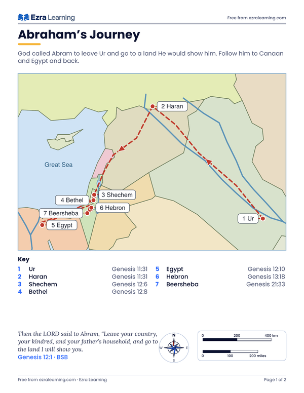
From Ur to Haran, Canaan and Egypt, with a Bible reference for every stop.
Genesis 12:1 BSB: Then the LORD said to Abram, “Leave your country, your kindred, and your father’s household, and go to the land I will show you.
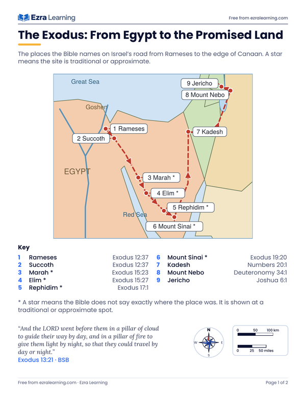
The places the Bible names from Rameses to Mount Nebo.
Exodus 13:21 BSB
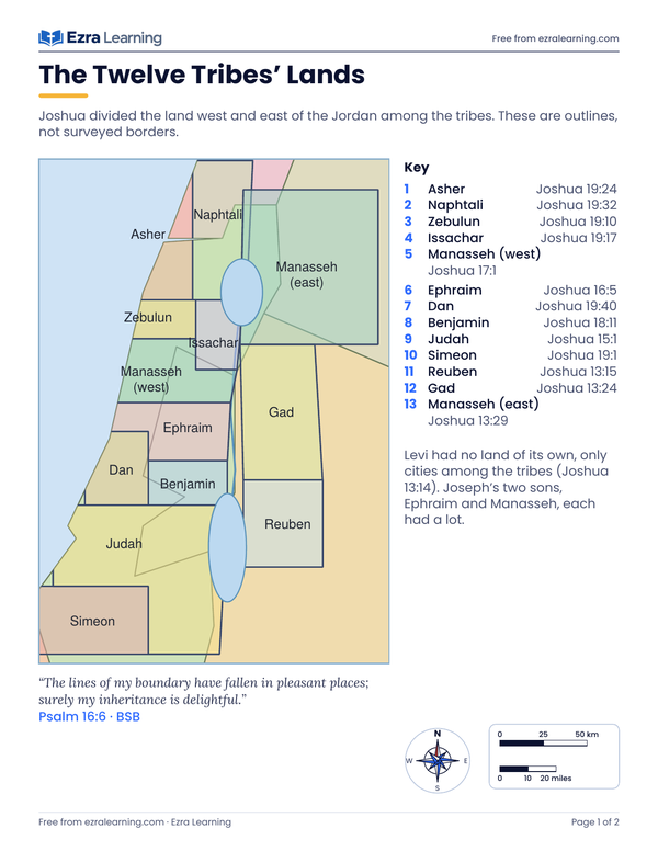
Outline map of the tribes’ lands with the names from Joshua.
Psalm 16:6 BSB: The lines of my boundary have fallen in pleasant places; surely my inheritance is delightful.
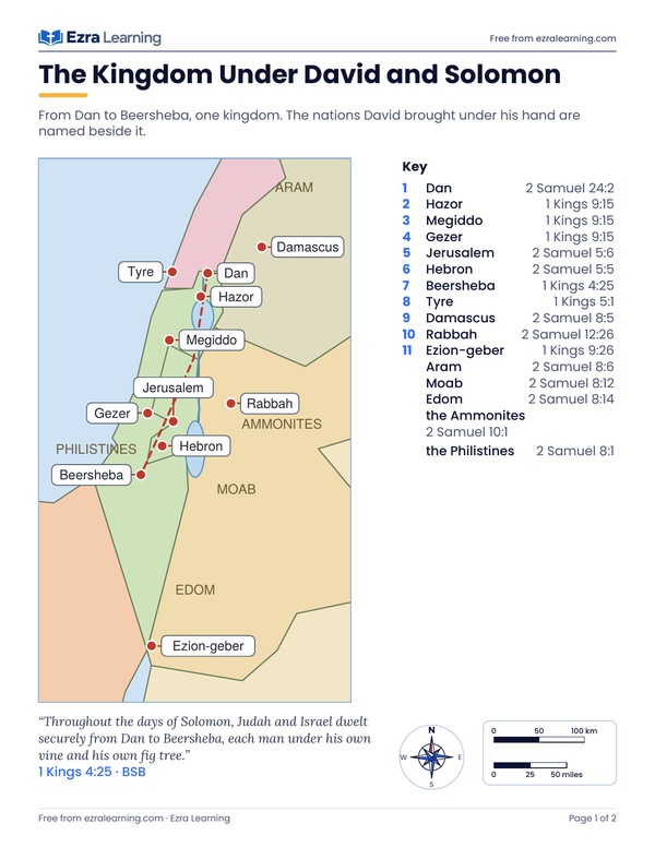
From Dan to Beersheba, and the nations beside it.
1 Kings 4:25 BSB: Throughout the days of Solomon, Judah and Israel dwelt securely from Dan to Beersheba, each man under his own vine and his own fig tree.
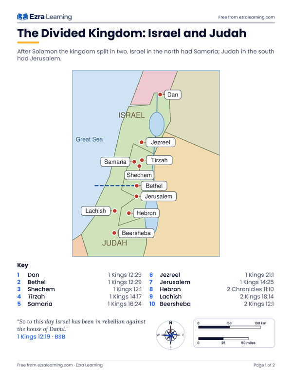
Israel in the north, Judah in the south, and their capitals.
1 Kings 12:19 BSB: So to this day Israel has been in rebellion against the house of David.
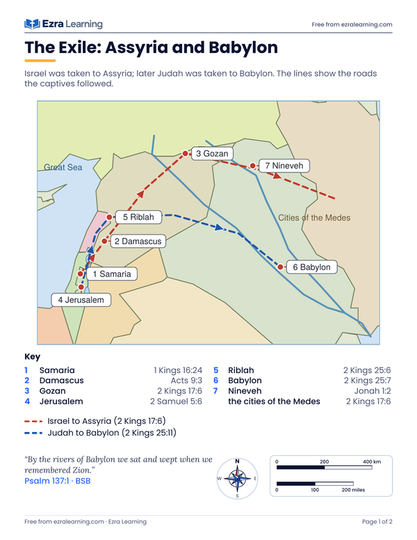
To Assyria and to Babylon: the two roads of the captives.
Psalm 137:1 BSB: By the rivers of Babylon we sat and wept when we remembered Zion.
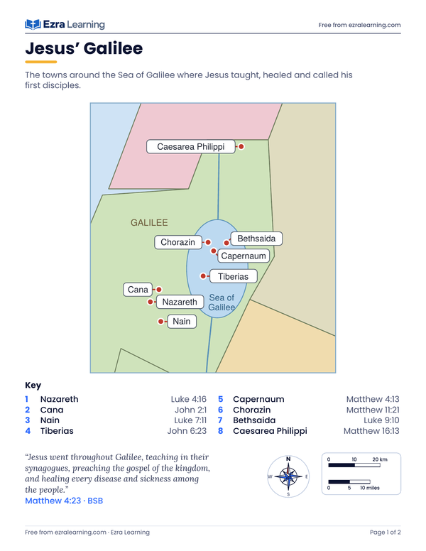
Nazareth, Cana, Capernaum and the towns around the Sea of Galilee.
Matthew 4:23 BSB: Jesus went throughout Galilee, teaching in their synagogues, preaching the gospel of the kingdom, and healing every disease and sickness among the people.
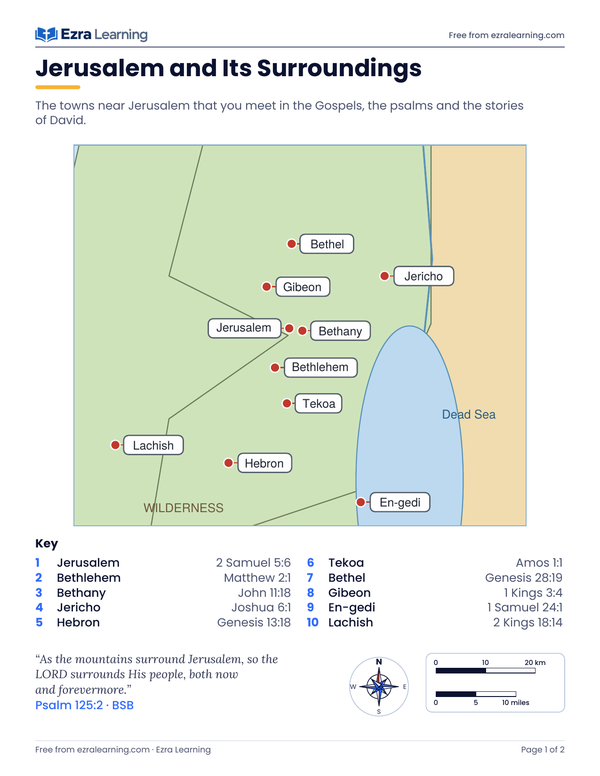
Bethlehem, Bethany, Jericho, Hebron and more, all within a day’s walk.
Psalm 125:2 BSB: As the mountains surround Jerusalem, so the LORD surrounds His people, both now and forevermore.
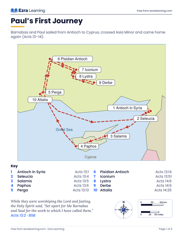
Cyprus and Asia Minor with Barnabas (Acts 13–14).
Acts 13:2 BSB: While they were worshiping the Lord and fasting, the Holy Spirit said, “Set apart for Me Barnabas and Saul for the work to which I have called them.”
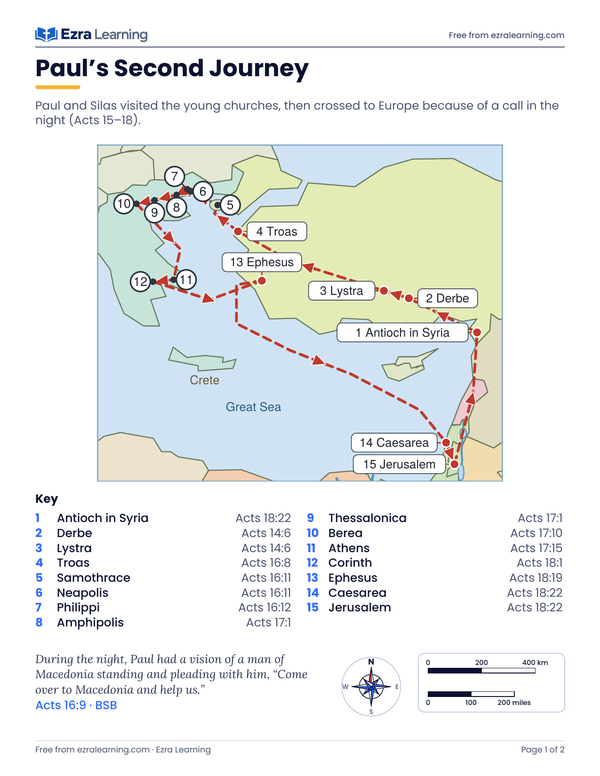
Across the sea to Philippi, Athens and Corinth (Acts 15–18).
Acts 16:9 BSB: During the night, Paul had a vision of a man of Macedonia standing and pleading with him, “Come over to Macedonia and help us.”
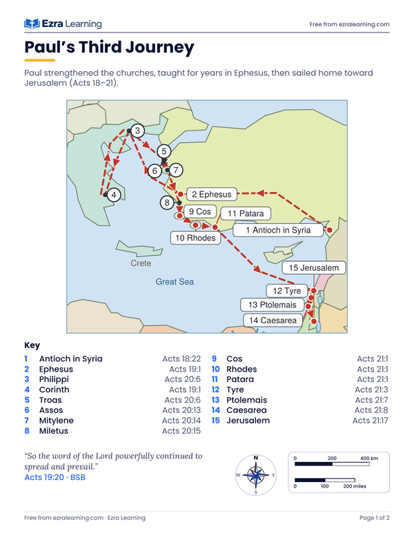
Ephesus, Greece and the sea road home to Jerusalem (Acts 18–21).
Acts 19:20 BSB: So the word of the Lord powerfully continued to spread and prevail.
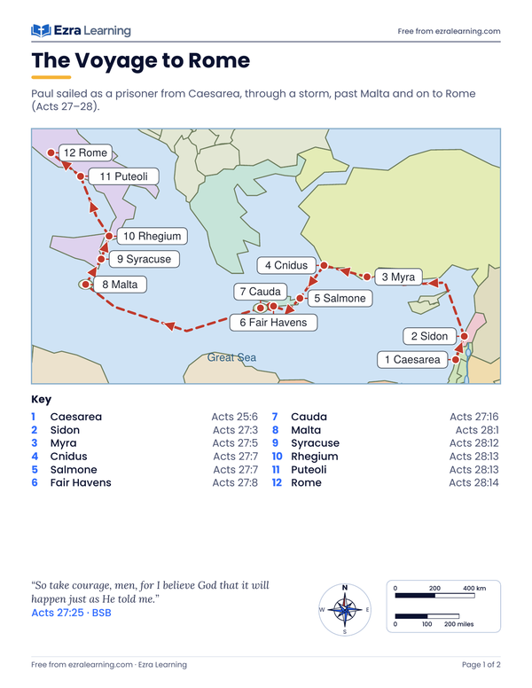
Caesarea to Rome by sea, through a storm (Acts 27–28).
Acts 27:25 BSB: So take courage, men, for I believe God that it will happen just as He told me.
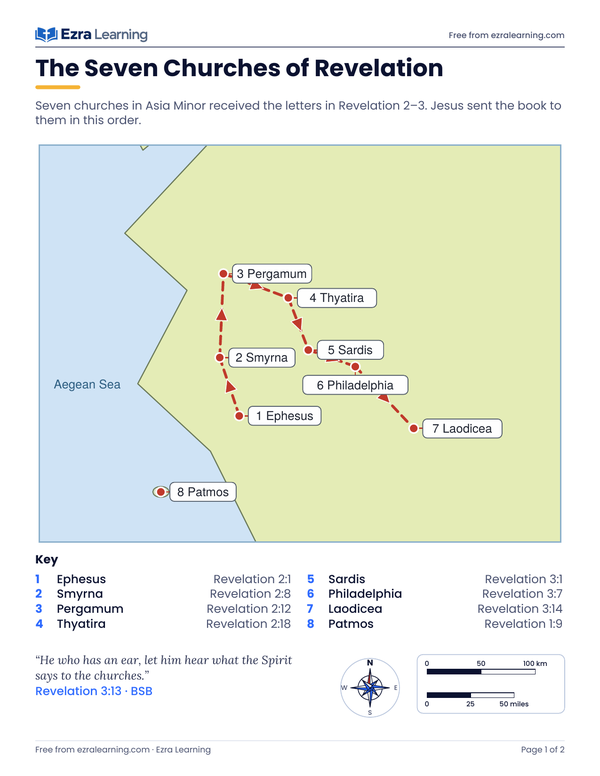
Ephesus to Laodicea, in the order of the letters.
Revelation 3:13 BSB: He who has an ear, let him hear what the Spirit says to the churches.
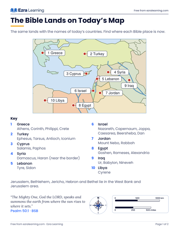
Today’s countries with the Bible places inside them.
Psalm 50:1 BSB: The Mighty One, God the LORD, speaks and summons the earth from where the sun rises to where it sets.
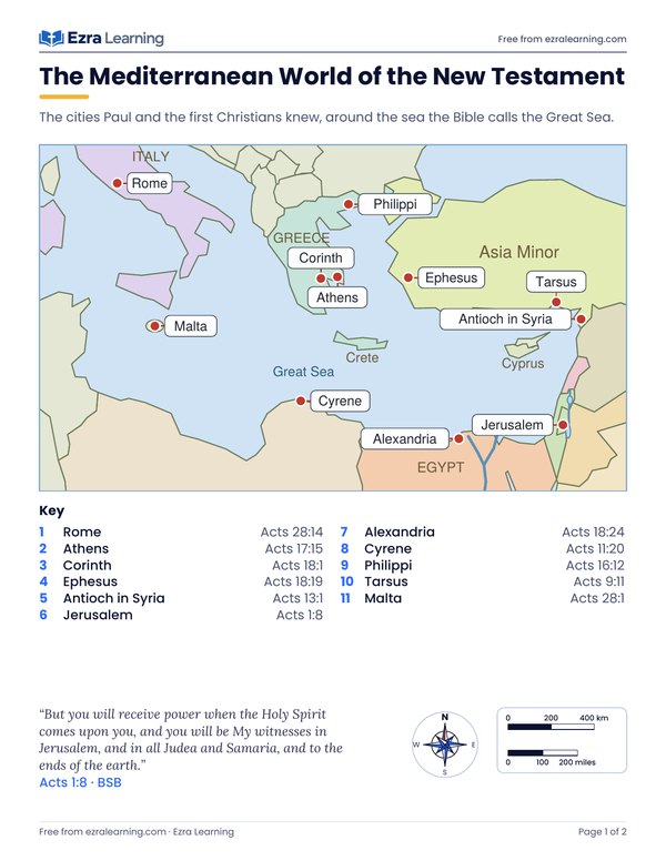
Rome, Athens, Ephesus, Antioch and Jerusalem around the Great Sea.
Acts 1:8 BSB
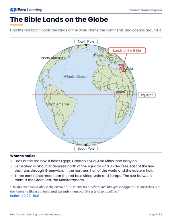
A globe with the Bible lands marked, labeled and blank.
Isaiah 40:22 BSB
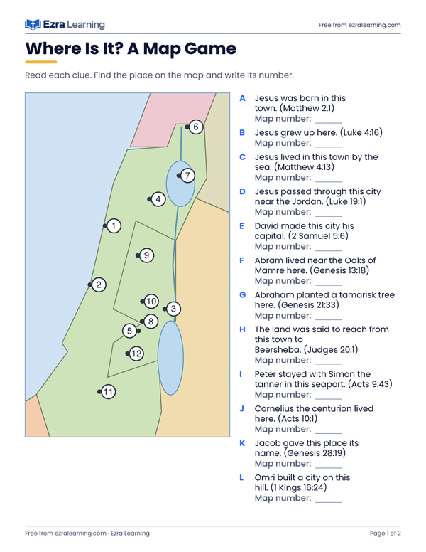
Twelve clues, twelve numbered dots, and an answer page.
Proverbs 3:6 BSB: in all your ways acknowledge Him, and He will make your paths straight.
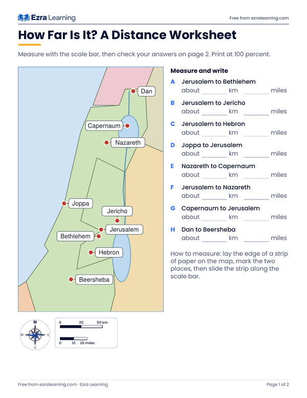
Measure straight-line distances with the scale bar; great-circle answers on page 2.
1 Samuel 3:20 BSB: So all Israel from Dan to Beersheba knew that Samuel was confirmed as a prophet of the LORD.
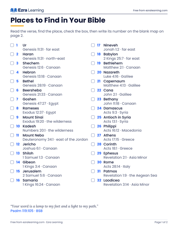
Thirty-two places with their references, and a blank map to mark them on.
Psalm 119:105 BSB: Your word is a lamp to my feet and a light to my path.
Free for your own family and co-op to print. Please do not sell them or put the PDFs on another site; share the link to this page instead.
All twenty maps are drawn from one coastline and one scale: the Mediterranean map in Ezra Learning’s own geography lessons. Every dot is placed from a written table of longitude and latitude, never by eye, and the distances on the worksheet are worked out from those same numbers (the straight-line, great-circle distance, rounded to the nearest 5). The twelve tribes’ lands are drawn as simple outlines, because Joshua gives the borders in words. Where the Bible does not say exactly where a place stood, the map says so with a star. Every verse is checked against the Berean Standard Bible text, and the pictures are objects only: a compass rose, a scale bar, a globe.
Yes. Every PDF downloads without an email address or an account, and you may print as many copies as your family or co-op needs. Each page carries “Free from ezralearning.com” at the bottom.
Page one is the labeled map with a key: the place names, numbered where there is a route, each with a Bible reference to read. Page two is the same map with the names taken off, a place to write them, a word bank, and a short coloring or tracing job. The three sheets that are not maps (the “where is it” game, the distance worksheet and the places-to-find list) have the sheet on page one and the answers or the blank map on page two.
The Berean Standard Bible (BSB), word for word. Each page that quotes a verse names the reference and the translation, and the key gives the verse where each place is named.
Each place is plotted from its published longitude and latitude on a map with a true scale bar, so the distances are real. The coastline is a simple one, drawn for learning, so a very small island or a harbor can sit a little off the true shore. The twelve tribes’ lands are outlines, not surveyed borders, and a few places that the Bible does not locate are marked with a star.
Children from about age 7 can label and color them. The labeled pages suit younger readers with a parent, the distance worksheet suits ages 9 and up, and the places-to-find list works well for a whole family reading together.
On Letter paper at 100 percent (“actual size”), because the scale bar on the distance worksheet is only right at that size. Black-and-white printing works; colored pencils are better on the blank page.
Narrated lessons, hands-on practice and a printable sheet for every lesson. Two sections of every subject and grade are free. No card, nothing to install.
Start free